Mapping the Critical Zone of Copenhagen: A “Terra Forma” inspired workshop
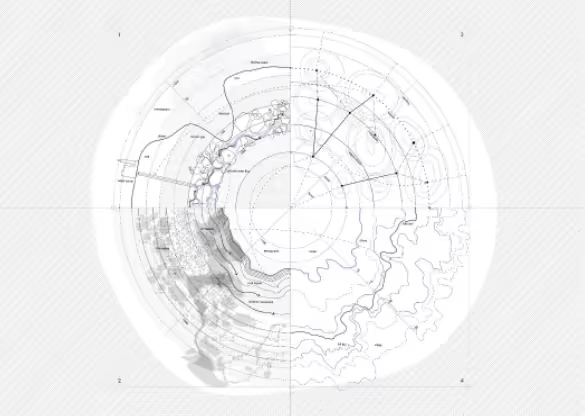
The “Critical Zone” is what Earth system scientists call the thin outer layer of the Earth where living things and resources coexist. Traditional cartographic frameworks often fail to capture this complex theatre of built and natural, biotic and abiotic relationships. Phenomena like pollution, erosion, and biodiversity loss, also escape these frameworks due scale, time and lack of representation in standardized mapping. This lecture, inspired by the learning of Terra Forma’ - a 2022 book on alternative cartography and mapmaking - drawing manual, invites the audience to experience an alternative map of Copenhagen and its relationship with the local environment – from the water and the rocks below the ground to the atmosphere above.
ㅤ
DAN:
”Den Kritiske Zone” er det, som jordsystemforskere kalder Jordens tynde yderste lag, hvor levende organismer og ressourcer sameksisterer. Traditionelle kartografiske rammer formår ofte ikke at fange dette komplekse samspil mellem det byggede og det naturlige, det biotiske og det abiotiske. Fænomener som forurening, erosion og tab af biodiversitet undslipper også disse rammer på grund af skala, tid og manglende repræsentation i standardiseret kortlægning. Denne forelæsning, inspireret af læringen fra Terra Forma’ – en bog fra 2022 om alternativ kartografi og kortfremstilling – tegnehåndbog, inviterer publikum til at opleve et alternativt kort over København og dets forhold til det lokale miljø – fra vandet og klipperne under jorden til atmosfæren ovenover.
so we can't show all the details just yet.